Viewshed Analysis for project planning
Custom viewshed analysis of your site
Save time and money
We know how hard it can be to find your tagged animals across vast landscapes – we’ve been there and done that too! So we’d love to help you better understand how you can cover the terrain you need to search with confidence and easily keep track of all your tagged animals.
Whether you work in rugged remote mountains, or in low-lying swamps and wetlands, our team can do a viewshed analysis of your sites and map out the survey coverage that is possible using traditional hand-held vs drone-based radio-telemetry.

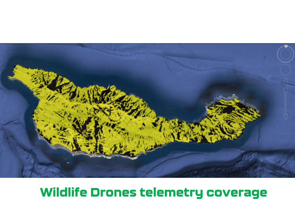
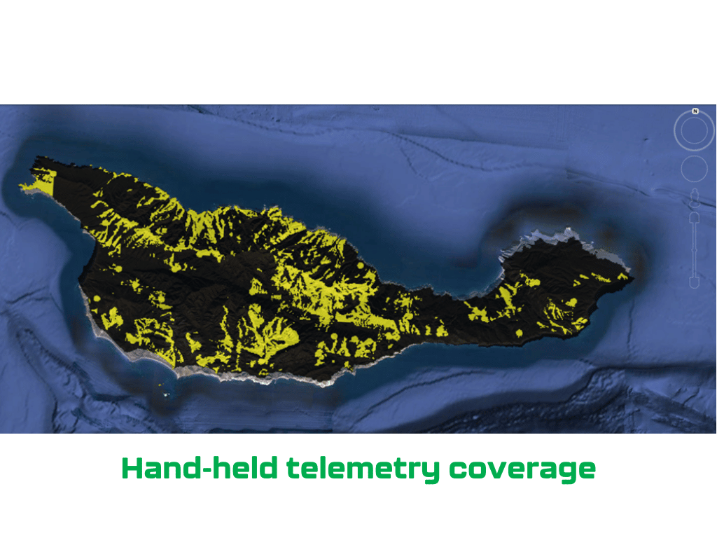
x3 more coverage 42,584 acres 12,615 acres
How to get started
Just send through a kml file of your site boundary, as well as any access tracks or points where a drone can be launched, and we can undertake a viewshed analysis for you, so you can see the survey coverage for yourself. You can then evaluate the benefits of using drone technology at your site, plan flights to maximise survey coverage before you head out into the field and gain confidence when searching for your tagged animals.
Get a free quote
The world’s most advanced drone radio-telemetry technology
Features and Benefits

Boost your radio-tracking power
Manually radio-tracking wildlife one at a time on foot is incredibly inefficient, especially in challenging terrain. With Wildlife Drones, you now have the ability to track up to 40 radio-tagged animals simultaneously. Importantly, this also reduces the risk of losing your tagged animals since it’s easier to track more animals more often.

Detects all types of VHF radio-tags
Our wildlife tracking and monitoring system is compatible with all very-high frequency (VHF) radio transmitters with inidividual frequencies. This includes radio-tags, collars and implant tags of all sizes from any manufacturer globally.
Wildlife Drones can even be used to remotely download data logs from GPS/VHF tags. Speak to our team about this today!

Real-time tracking and mapping
Rapidly radio-track and locate your animals in real-time. View animal locations live on a map, even when offline. Use this data to help recover tagged animals on the ground, implement more targeted management efforts and more.

Ultimate flexibility in the field
We’ve made radio-tracking wildlife more efficient. With our wildlife tracking and monitoring system, fieldwork has never been easier. Deploy our system whenever and wherever needed and collect all the data you need in just a few flights.
Perfect for the field
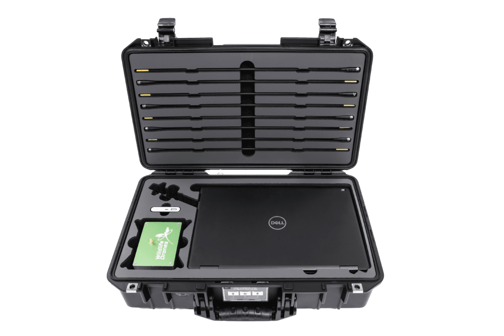
The world’s most advanced drone-based animal tracking technology
Housed in a rugged Pelican™ case, the Wildlife Drones system comes with everything you need to quickly set up in the field and start tracking. The system includes the following components:
- Custom VHF antenna and radio receiver.
- Long-range communication system sends tracking data to the base station.
- Base station laptop which maps all data in real-time and comes with Wildlife Drones’ tracking app pre-installed.
Free worldwide shipping included with every order!
Get in touch now to find out more and start tracking.

Thermal Imaging
Make the invisible visible with thermal drone technology. Spot nocturnal and cryptic animals easily regardless of whether they are tagged or not.

Drone Pilot Training
Whatever your level of experience, our team of experts can provide all the training you need to use drones for tracking animals.


